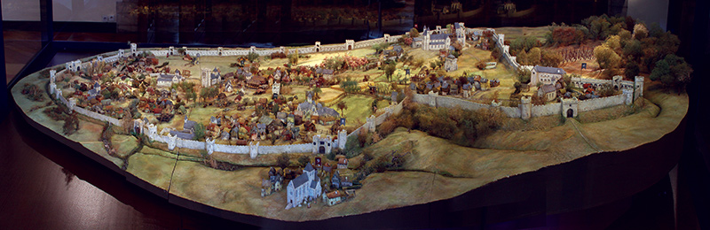
Model created by Claire Louis in 2001
The museum commissioned the creation of this model based on knowledge gleaned from medieval written and illustrated documents, archaeological excavations and comparisons with other cities, as well as subsequent maps of Brussels. If we look at it standing in the direction of the Grand-Place, the model is facing south. It has been created for illustrative purposes, which is why the buildings have been oversized and their number reduced. It is estimated that in the middle of the 13th century, the city was home to between 5,000 and 10,000 inhabitants. We invite you to take a closer look by following the flags numbered 1 to 12.
The port on the river Senne
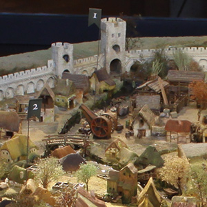 At flag number 1, we begin our journey at the port of Brussels. The pier on the bank of the river Senne abounds with various goods that have been transported there by flat-bottomed boats. The heaviest loads are lifted by a wooden crane. The bridge spanning the Senne is called the 'Pont des Bateaux’ (“Bridge of Boats”). This is where the original port is located, probably dating back to the 10th century. At that time, panels on the bridge could be raised in order to load or unload goods from the boats passing underneath.
Saint-Géry Island
 Number 2 indicates Saint-Géry Island, encircled by the arms of the Senne. The island did not form naturally, but is the result of diversions dug in the river in order to power water mills. The district owes its name to the church dedicated to Saint Géry.
The Lower Market
 Number 3 shows what the current Grand-Place may have looked like at the time. It was called the “Lower Market”. Established during the 12th or 13th century on former pastures, it was the largest commercial space in the city. On its north side, the square is bordered by the bread hall, a wood-frame building serving as a covered market for bakers. Today, this location is home to the Brussels City Museum, which you are currently visiting.
The Franciscan convent
 Number 4 marks the Franciscan convent. By this time, the brothers of the mendicant order of Saint Francis of Assisi had established their community in the lower part of the city, home primarily to the working class and trade. These religious men did not live in seclusion. On the contrary, they forged important links with the community. Many Brussels residents came to listen to their sermons. Excavations have revealed the remains of this convent, next to the current Stock Exchange building (the “Bourse”).
The Chaussée
 Number 5 invites you to take a stroll down the Chaussée (the “roadway”) which was the only paved highway at the time. This roadway is the city's most significant axis, connecting both its upper and lower districts. The lower half is also a major commercial artery.
The Castle of the Dukes of Brabant
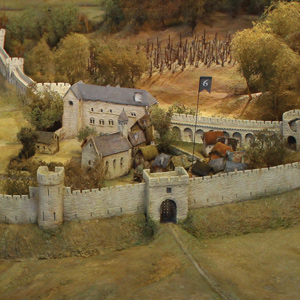 Number 6 marks the Castle of the Dukes of Brabant on Coudenberg Hill, most likely built at the beginning of the 12th century. When in Brussels, it was here that the Duke resided with his Court and ran his government. The rear wall of the castle has been integrated into the city walls. Some remains of the building can be seen at the archaeological site of the Coudenberg Palace in the Place Royale district.
The Cantersteen
 Number 7 shows the Cantersteen, one of the stone-built residences that were constructed by only the richest families in Brussels. There are very few of them. All the other houses in the city are thatched cottages with roofs covered in straw and wattle-and-daub filled wooden frames.
The city wall
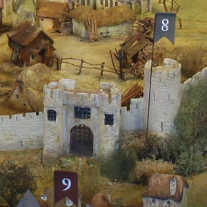 Number 8 highlights one of the towers in the defensive wall which surrounds Brussels and is about 4 kms long. This initial stone enclosure, having been preceded by ditches, was built in the early half of the 13th century. It has seven fortified gates which regulate entry into the city and allow tax to be levied on goods. This tower, known much later as Anneessens Tower, still survives today. It can be seen on the current Boulevard de l'Empereur.
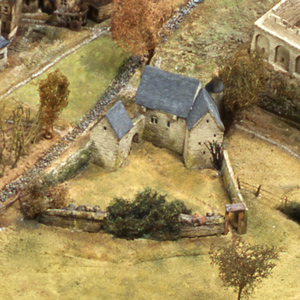
Notre-Dame de la Chapelle
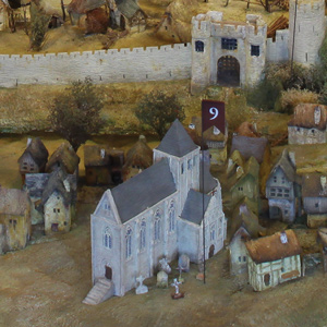 Number 9 takes you to a suburb, in other words a district that has developed outside the city walls. Many workers active in the construction, tannery and textile sectors could be found there. The main road through the district is the Rue Haute. The parish church of Notre-Dame de la Chapelle was built on this axis in several phases during the 13th century.
The corn exchange
 Number 10 designates the corn exchange, a wood-frame construction built in the 13th century to house the grain market.
Saint-Jean hospital
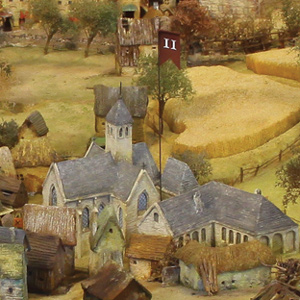 Number 11 indicates the Saint-Jean hospital which, for a short period, received poor patients who could no longer walk or beg, destitute pregnant women and abandoned children. They were permitted to attend religious services at the adjoining church.
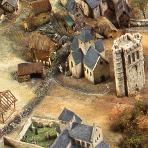
The collegiate church of Saint Michael and Saint Gudula
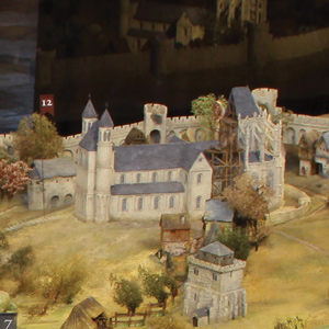 Number 12 takes us to a hill occupied by the most important church in the city. It is dedicated to both Saint Michael and Saint Gudula. Served by a community of canons financed by the Duke of Brabant, it bears the title of collegiate church. It is the religious heart of the city. It is also the location of the first school in Brussels. Built in the Romanesque style, the chancel of the church was gradually rebuilt from the 1220s onwards in the Gothic style.
Now let us move to the oldest blueprint on display in this room.


